The mission of this division of the Planning and Community Development Department is to provide decision and policy makers within the city information needed to effectively manage the city’s resources in a format that can be easily understood and visualized in a fashion that allows patterns and relationships to be discerned. In order to fulfill this mission, GIS Services maintains geographically enabled databases documenting all the major components of the infrastructure and legally mandated management zones for the City of Norman. These databases include, but are not limited to: wastewater collection system, water distribution system, storm water collection system, zoning, Norman 2025 land use plan, city council wards, historic districts, recoupment districts, property ownership patterns, street centerlines, building footprints, paving, fences, trees, police beats, fire districts, sanitation routing, topography, hydrography, and digital aerial orthophotography.
This division exists because the majority of the resources that a city must manage (sewer line, water lines, streets) and the services it must provide (water or trash service to a residence, calls for police or fire service) have a geographic component. Creating databases organized around geography allows the content to be modeled and visualized more effectively. The capacity to link data, which previously did not exist or was stored in unrelated tables, facilitates more creative and efficient problem solving and service delivery citywide.
Mapping Applications and Resources
Open Data & Mapping
The City of Norman provides the Open Data and Mapping Site to allow citizens and employees explore mapping applications, access GIS data and in some cases download GIS data.
Interactive Map
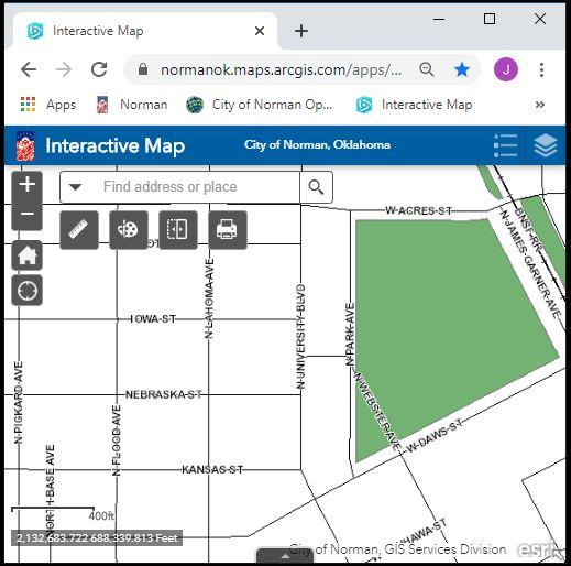
The map provides display and identify access to many of the City's GIS layers. The data are to be used for general reference only. All data are provided as is, with all faults, and without warranty of any kind, expressed or implied, including but not limited to, the implied purpose. The City of Norman does not warrant that the data will meet your requirements nor that operation of the data and/or application will be uninterrupted and error free. Maps and data generated using these applications may be e-mailed or printed, with the understanding that they will be used for general reference only, without any claims of completeness or accuracy.